

The Unnamed Plateau (Western Desert of Egypt). New geological and geoarchaeological data from an exploration in a remote area
All claims expressed in this article are solely those of the authors and do not necessarily represent those of their affiliated organizations, or those of the publisher, the editors and the reviewers. Any product that may be evaluated in this article or claim that may be made by its manufacturer is not guaranteed or endorsed by the publisher.
Published: 19 May 2023
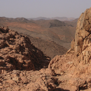
The Unnamed Plateau is a low plateau in the Western Desert of Egypt close to the Libyan border, about halfway between the Gilf Kebir to the north and Jebel Uweinat to the south. It is little known and seldom visited. In the past, we have conducted three field surveys in order to assess its geomorphic features and the human presence in the Holocene. During our explorations we have found a Paleozoic fossil plant, which allows to ascribe the sedimentary cover to the late Paleozoic (as in the Geologic Map of Egypt, 1981), not Mesozoic, as indicated in the 1987 Geologic Map. We could retrace and walk an ancient mountain path connecting the two slopes of the Plateau and leading to a fossil lake. The area was visited by hunters-gatherers and perhaps the first nomadic herders moving north-south, until the mid-IV Millennium BC, when the final desiccation of the Eastern Sahara pushed them out definitely.
Downloads
Almásy L., 2004 − Sahara Sconosciuto. Nutrimenti. Roma. [Original edition: Unbekannte Sahara. Leipzig, 1939].
Bagnold R. A., Myers O. H., Peel R. F. & Winkler H. A., 1938 − An Expedition to the Gilf Kebir and ’Uweinat, 1938. The Geographical Journal, 93 (4): 281-312. DOI: https://doi.org/10.2307/1787767
Brügge N., 2018 − Carboniferous plant imprints in the Western Desert (Egypt/Sudan). <http://www.b14643.de/Sahara/Fossil-Plants>
Brügge N., 2020 − Structure and Geology of Jebel Uweinat in the three country triangle Egypt-Sudan-Libya. <http://www.b14643.de/Sahara/Geology_Jebel-Uweinat>
Cambieri F. & Peroschi M. E., 2018 − Jebel Uweinat: Sulle orme di G. Negro e V. De Michele. Zerzura Meeting “SILICA 18”. S. Giovanni in Persiceto, 15-16 settembre 2018: 58-77.
Clayton P. A., 1933 − The Western Side of the Gilf Kebir. The Geographical Journal, 81 (3): 254-259. <https://doi.org/10.2307/1784041> DOI: https://doi.org/10.2307/1784041
Conoco Coral & Egyptian General Petroleum Corporation (eds.), 1987 – Geological map of Egypt 1:500.000, NF 35 NW Gilf Kebir Plateau. Conoco, Cairo.
Czekaj-Zastawny A., Irish J. D., Kabaciński J. & Mugaj J., 2018 – The Neolithic settlements by a paleo-lake of Gebel Ramlah, western desert of Egypt. Desert and the Nile. Prehistory of the Nile basin and the Sahara. Papers in honour of Fred Wendorf. African Archaeology 15. Poznań Archaeological Museum: 515-538.
Desio A., 1950 − Le vie della sete. Hoepli, Milano. Egyptian Geological Survey and Mining Authority, 1981 – Geologic map of Egypt, scale 1:2.000.000. EGSMA, Cairo.
El-Baz F., 1980 − Journey to the Gilf Kebir and Uweinat, Southwest Egypt, 1978. Narrative of the Journey. The Geographical Journal, 146 (1): 51-59. DOI: https://doi.org/10.2307/634069
el Dine Hussein K., 1928 − L’Exploration du Désert Libyque. La Géographie, L (3-4): 171-183; (5-6): 320-336.
Ghoneim E., Benedetti M. & El-Baz F., 2012 − An integrated remote sensing and GIS analysis of the Kufra Paleoriver, Eastern Sahara. Geomorphology, 139-140: 242-257. <https://doi.org/10.1016/j.geo-morph.2011.10.025> DOI: https://doi.org/10.1016/j.geomorph.2011.10.025
Harding King W. J., 1913 − The Libyan Desert from Native Information. The Geographical Journal, 42 (3): 277-283. <https://doi.org/10.2307/1778761> DOI: https://doi.org/10.2307/1778761
Harris N. B. W., Hawkesworth C. J. & Ries A. C., 1984 − Crustal evolution in north-east and east Africa from model Nd ages. Nature, 309: 773-776. DOI: https://doi.org/10.1038/309773a0
Hassan F. A., Barich B., Mahmoud M. & Hemdan M. A., 2001 – Holocene Playa Deposits of Farafra Oasis, Egypt, and their Plaeoclimatic and Geoarchaeological Significance. Geoarchaeology: An International Journal, 16 (1): 29-46. DOI: https://doi.org/10.1002/1520-6548(200101)16:1<29::AID-GEA4>3.0.CO;2-O
Hassanein Bey A., 2006 − The Lost Oases. The American University in Cairo Press, Cairo. [First published in 1925. Thornton Butterworth. London].
Hoelzmann P., Keding B., Berke H., Kröpelin S. & Kruse H.-J., 2001 – Environmental change and archaeology: lake evolution and human occupation in the Eastern Sahara during the Holocene. Palaeogeography, Palaeoclimatology, Palaeoecology, 169: 193-217. DOI: https://doi.org/10.1016/S0031-0182(01)00211-5
Klerkx J. & Deutsch, S. - 1977 - Résultats préliminaires obtenus par la méthode Rb/Sr sur l’âge des formations précambriennes de la region d’Uweinat (Libye). Rapport Annuel pour l’Année 1976 du Département de Géologie et de Minéralogie du Musée Royale de l’Afrique Central: 83-94.
Kröpelin S., 1987 − Palaeoclimatic evidence from early to mid-Holocene playas in the Gilf Kebir (south-west Egypt). Palaeoecology of Africa, 18: 189-208.
Kuper R., 1993 − Sahel in Egypt: environmental change and cultural development in the Abu Ballas area, Libyan Desert. In: Environmental Change and Human Culture in the Nile Basin and Northern Africa until the Second Millennium B.C. Krzyzaniak L., Kobusiewicz M. & Alexander J. (eds.). Poznan Archaeological Museum, Poznań: 213-223.
Kuper R. (ed.), 2013 – Wadi Sura - The Cave of Beasts. A rock art site in the Gilf Kebir (SW-Egypt). Africa Praehistorica 26. Heinrich Barth Institut, Köln.
Kuper R. & Kröpelin S., 2006 − Climate-controlled Holocene Occupation: motor of Africa’s evolution. Science, 313 (5788): 803-807. <http://dx.doi.org/10.1126/science.1130989> DOI: https://doi.org/10.1126/science.1130989
Kuper & Riemer, 2010 − Archaeological Survey at Western Jebel Ouenat, SE Libya. Libya antiqua, Annual of the Department of Archaeology of Libya, V: 189-199.
Lejal-Nicol A., 1990 – Fossil flora. In: Geology of Egypt. R. Said (ed.). A.A. Balkema, Rotterdam-Brookfield: 615-626. DOI: https://doi.org/10.1201/9780203736678-29
Linstädter J. & Kröpelin S., 2004 – Wadi Bakht revisited: Holocene climate change and prehistoric occupation in the Gilf Kebir region of the Eastern Sahara, SW Egypt. Geoarchaeology: An International Journal, 19 (8): 753-778. <https://doi.org/10.1002/gea.20023> DOI: https://doi.org/10.1002/gea.20023
McHugh W. P., McCauley J. F., Haynes C. V., Breed C. S. & Schaber G. G., 1988 – Paleorivers and Geoarchaeology in the Southern Egyptian Sahara. Geoarchaeology: An International Journal, 3 (1): 1-40. DOI: https://doi.org/10.1002/gea.3340030102
Neumann K., 1989 − Holocene vegetation of the Eastern Sahara: charcoal from Prehistoric sites. African Archaeological Review, 7: 97-116. DOI: https://doi.org/10.1007/BF01116839
Nicoll K., 2004 − Recent environmental change and prehistoric human activity in Egypt and Northern Sudan. Quaternary Science Reviews, 23 (5-6): 561-580. <https://doi.org/10.1016/j.quascirev.2003.10.004> DOI: https://doi.org/10.1016/j.quascirev.2003.10.004
Peroschi M. E. & Cambieri F., 2010 − Noteworthy stone structures and monoliths recently found in Wadi Abd el-Malik (Gilf Kebir, Egypt). Sahara, 21: 206-209.
Peroschi M. E. & Cambieri F., 2018 − Recenti esplorazioni nel Deserto Libico. Archeologia Africana - Saggi Occasionali, 20/24, (2014/2018): 43-52.
Peroschi M. E., Cambieri F. & De Santis M. L., 2018 − Jebel Uweinat: More than Rock Art. In: Nubian Archaeology in the XXIst Century. Proceedings of the Thirteenth International Conference for Nubian Studies, Neuchâtel, 1st-6th September 2014. Honegger M. (ed.). Orientalia Lovaniensia Analecta, Peeters Publishers, 273: 223-230. DOI: https://doi.org/10.2307/j.ctv1q26wt1.19
Peroschi M. E., Cambieri F. & De Cola L., 2021 − Un riparo ai margini di Jebel al-’Uweynât (Sudan). Note geoarcheologiche. Les Cahiers de l’AARS, 22: 129-138.
Richter A. & Schandelmeier H., 1990 − Precambrian basement inliers of Western Desert geology, petrology and structural evolution. In: Geology of Egypt. A. Said (ed.). A.A. Balkema, Rotterdam-Brookfield: 185-200. DOI: https://doi.org/10.1201/9780203736678-11
Riemer H., 2013 – Dating the rock art of Wadi Sura. In: Wadi Sura - The Cave of Beasts. A rock art site in the Gilf Kebir (SW-Egypt). Africa Praehistorica 26. Kuper R. (ed.). Heinrich Barth Institut, Köln: 34-37.
Riemer H., Kröpelin S. & Zboray A., 2017 − Climate, styles and archaeology: an integral approach towards an absolute chronology of the rock art in the Libyan Desert (Eastern Sahara). Antiquity, 91 (355): 7-23. <https://doi.org/10.15184/aqy.2016.252> DOI: https://doi.org/10.15184/aqy.2016.252
Survey of Egypt, 1942 − Egypt 1:500.000, Sheet 10: ‘Uweinât. Survey of Egypt, Cairo.
Wendorf F. & Schild R. (eds.), 2001 − Holocene Settlement of the Egyptian Sahara. Volume 1: The Archaeology of Nabta Playa. Kluwer Academic / Plenum Publishers, New York, Boston, Dordrecht, London, Moscow.
Zboray A., 2002 − Jebel Uweinat-Gilf Kebir Expedition, 20th October - 5th November, 2002. The Libyan Desert past trip accounts. <https://www.fjexpedi-tions.com/frameset/past.htm>
Zboray A., 2009 − Rock art of the Libyan Desert. Second Expanded Edition. Fliegel Jezerniczky Expeditions Ltd, Newbury, UK. (DVD).
Zboray A., 2021 − The Petroglyphs of Jebel Uweinat. Many Questions and a Few Answers. In: Desert and the Nile. Prehistory of the Nile Basin and the Sahara. Papers in honour of Fred Wendorf. Kabaciński J., Chłodnicki M., Kobusiewicz M. & Winiarska-Kabacińska M. (eds.). Poznań Archaeological Museum, Studies in African Archaeology, 15: 707-733. <https://doi.org/10.11588/propylaeum.830.c10661>
Zboray A. & Borda M., 2010 − Some recent results of the survey of Jebel Uweinat. Sahara, 21: 181-189.
Zerboni A., Perego A. & Cremaschi M., 2015 − Geomorphological Map of the Tadrart Acacus Massif and the Erg Uan Kasa (Libyan Central Sahara). Journal of Maps, 11 (5): 772-787. <https://doi.org/10.1080/17445647.2014.955891> DOI: https://doi.org/10.1080/17445647.2014.955891
How to Cite

This work is licensed under a Creative Commons Attribution-NonCommercial 4.0 International License.
PAGEPress has chosen to apply the Creative Commons Attribution NonCommercial 4.0 International License (CC BY-NC 4.0) to all manuscripts to be published.